Technology During the Age of Exploration
"As more explorers took to the sea, improvements in sailing vessels, navigation, cartography, and geography rapidly followed."
There were many technology advancements during the Age of Exploration.
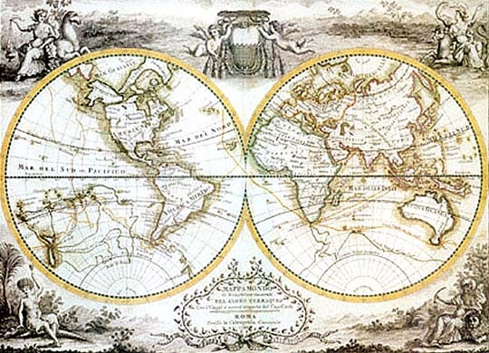
1.Cartography- In 1477, Ptolemy's map only showed 3 continents and 2 oceans. Due to the Age of Exploration, these maps were highly improved." An instrument called a quadrant was used to sight a particular star or the sun, and then the angle between the horizon, the star, and the navigator was measured. Latitude could then be calculated from this measurement. However, longitude was another problem altogether; to be able to calculate longitude, one needed to know exactly what date and time it was to complete the celestial calculation."
Methods of finding Longitude were created and used. This highly advanced navigation while exploring. The new maps also showed distance between ports and coastlines. See image at the bottom of the page for an example of an Age of Exploration map.
2.Compass- The compass tells direction using the poles (North Pole and South Pole).
"However, the first people to make a practical compass, that is, a magnetized needle supporting a compass card showing four or eight points of direction, seemed to be the Venetians in 1274. It was likely a valuable trade secret, so they didn't tell anyone. But after the year 1311, pictures showing maritime subjects all have a compass featured in them."
3.Astrolabe- The North star is not visible south of the Equator, so the astrolabe uses latitude for navigation.
" It was possibly invented by the Greek astronomer and mathematician, Hipparchus (190-120 BCE). However, in its earliest uses, it was for astronomy and astrology. Only when the need to measure angular heights of Polaris became important did we see these instruments adopted for sea-going use. As an astronomer's tool, the Astrolabe was introduced to the Europeans by Arab astronomers in the 10th century, CE. But the first documented use of it used at sea is in 1481 on a voyage down the African coast by Portuguese explorers. It is likely, though, that it was in use by sailors for many years before that."
4.Knowledge of Wind Patterns- The explorers had a new knowledge of wind patterns. With this knowledge, the seas would be easier to navigate using sails.
5.Ships- They had new sea-worthy ships known as caravels. Caravels were the ships that were used the most for exploring.
"In the 1440s, a caravel style ship could be found in the Atlantic Sea and the Mediterranean Sea. These small-to-medium size ships were used as cargo carriers, warships, patrol or dispatch boats, and pirate ships. The earliest evidence of the caravel was on the Iberian Peninsula in the 13th Century."
There were many technology advancements during the Age of Exploration.
1.Cartography- In 1477, Ptolemy's map only showed 3 continents and 2 oceans. Due to the Age of Exploration, these maps were highly improved." An instrument called a quadrant was used to sight a particular star or the sun, and then the angle between the horizon, the star, and the navigator was measured. Latitude could then be calculated from this measurement. However, longitude was another problem altogether; to be able to calculate longitude, one needed to know exactly what date and time it was to complete the celestial calculation."
Methods of finding Longitude were created and used. This highly advanced navigation while exploring. The new maps also showed distance between ports and coastlines. See image at the bottom of the page for an example of an Age of Exploration map.
2.Compass- The compass tells direction using the poles (North Pole and South Pole).
"However, the first people to make a practical compass, that is, a magnetized needle supporting a compass card showing four or eight points of direction, seemed to be the Venetians in 1274. It was likely a valuable trade secret, so they didn't tell anyone. But after the year 1311, pictures showing maritime subjects all have a compass featured in them."
3.Astrolabe- The North star is not visible south of the Equator, so the astrolabe uses latitude for navigation.
" It was possibly invented by the Greek astronomer and mathematician, Hipparchus (190-120 BCE). However, in its earliest uses, it was for astronomy and astrology. Only when the need to measure angular heights of Polaris became important did we see these instruments adopted for sea-going use. As an astronomer's tool, the Astrolabe was introduced to the Europeans by Arab astronomers in the 10th century, CE. But the first documented use of it used at sea is in 1481 on a voyage down the African coast by Portuguese explorers. It is likely, though, that it was in use by sailors for many years before that."
4.Knowledge of Wind Patterns- The explorers had a new knowledge of wind patterns. With this knowledge, the seas would be easier to navigate using sails.
5.Ships- They had new sea-worthy ships known as caravels. Caravels were the ships that were used the most for exploring.
"In the 1440s, a caravel style ship could be found in the Atlantic Sea and the Mediterranean Sea. These small-to-medium size ships were used as cargo carriers, warships, patrol or dispatch boats, and pirate ships. The earliest evidence of the caravel was on the Iberian Peninsula in the 13th Century."
John Cook's World Map